


camping les Bouleaux Refuge Vallonpierre

Danielba
User GUIDE
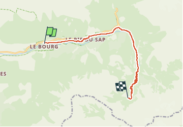

Length
10.9 km

Max alt
2276 m

Uphill gradient
1175 m
Km-Effort
23 km

Min alt
1176 m

Downhill gradient
77 m
Boucle
No
Creation date :
2023-04-22 15:02:22.81
Updated on :
2023-04-22 15:02:56.46
5h11
Difficulty : Very difficult

FREE GPS app for hiking
 SityTrail
IGN / Geographical institutes
SityTrail Plus
The world is yours!
About
Trail Walking of 10.9 km to be discovered at Provence-Alpes-Côte d'Azur, Hautes-Alpes, La Chapelle-en-Valgaudémar. This trail is proposed by Danielba .
Positioning
Country:
France
Region :
Provence-Alpes-Côte d'Azur
Department/Province :
Hautes-Alpes
Municipality :
La Chapelle-en-Valgaudémar
Location:
Unknown
Start:(Dec)
Start:(UTM)
281245 ; 4967196 (32T) N.
Comments